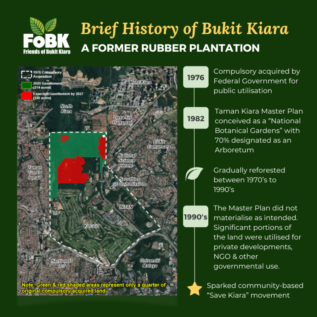
Bukit Kiara Estate was the first of three rubber estates that were compulsorily acquired by the Federal Government following the creation of the Federal Territory of Kuala Lumpur in 1974. While the other two acquisitions — the Hawthornden estate (now Wangsa Maju) and the Bukit Jalil estate (now Bukit Jalil) — were made to accommodate urban population expansion, the overriding objective of the Bukit Kiara Estate acquisition was for public purpose.
Forty-nine million Ringgit (RM49 million) of public funds was spent to acquire Bukit Kiara Estate from Ng Chin Siu & Sons plus a few adjacent smallholdings; 1,534 acres in total. A portion of the land was set aside for a National Institute of Public Administration (INTAN), National Science Centre and other public institutions and facilities. Dewan Bandaraya Kuala Lumpur (DBKL) then commissioned world-renowned landscape architect firm Royston Hanamoto Alley & Abey to develop a master plan for the remaining area. The resultant 1982 Taman Kiara Master Plan conceived a “National Botanical Gardens” comprised of a 650-acre arboretum in the north, which would merge into a park-like National Mausoleum and public golf course in the south.
Against a backdrop of rapid economic growth of the early 1990s, the implementation of the Master Plan did not go according to plan. A significant portion of the area that was zoned for public purpose fell into private hands. It was this loss of public land that sowed the seeds of activism within the local community; a movement that was initially led by the Taman Tun Dr. Ismail Residents’ Association. The Friends of Bukit Kiara (FoBK), which was registered as a Society in 2014, has been at the forefront of the Save Bukit Kiara movement since 2001 when it began as a coalition of Residents’ Associations from across the KL-PJ conurbation.
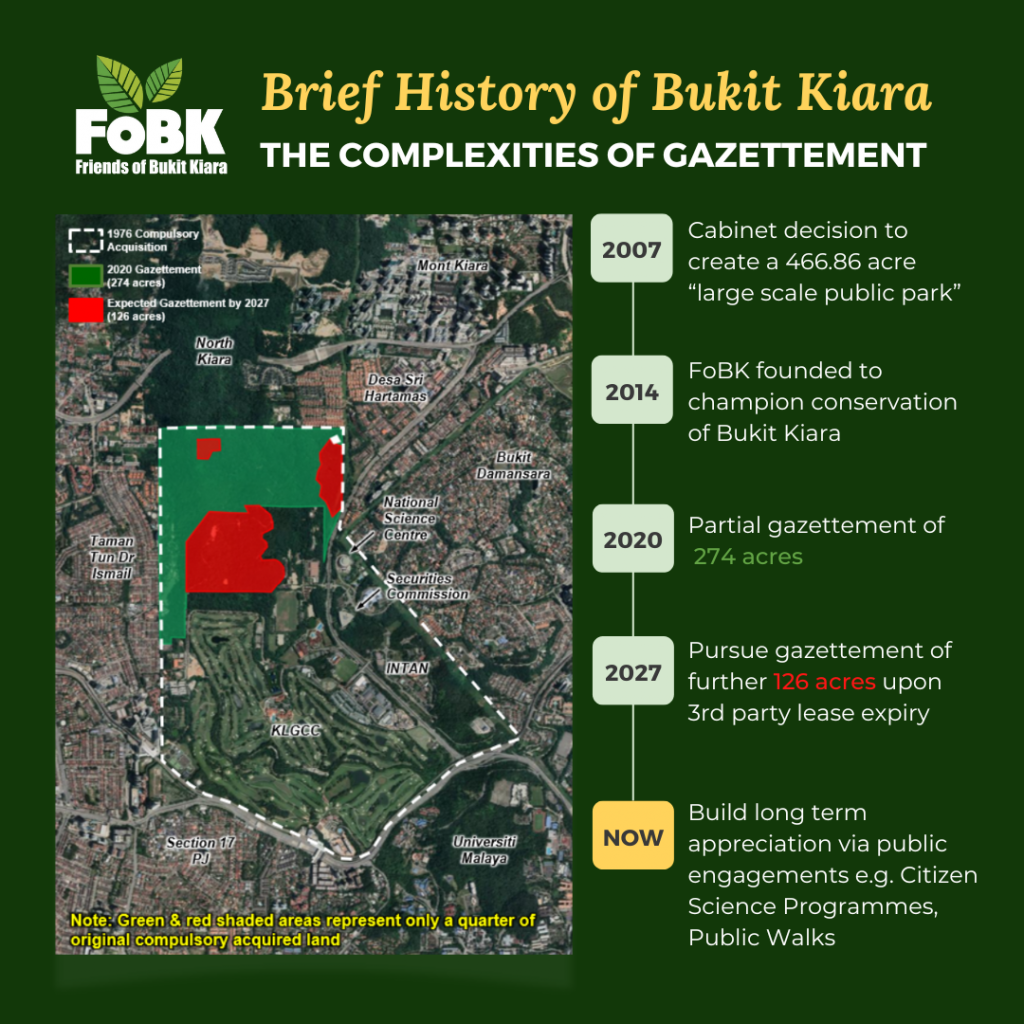
Two major milestones have been achieved in our conservation journey thus far.
- The first was a Federal Cabinet decision in June 2007 to create a 466.86-acre “large-scale public park” at Bukit Kiara.
- The second was the (partial) implementation of the said decision in July 2020, via the gazettement of approximately 274 acres as “Bukit Kiara Federal Park” under the National Land Code 1965.
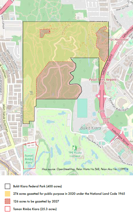
Today, the Bukit Kiara Federal Park, which has been managed by the National Landscape Department since 2010, spans 400 acres — less than the 466.86 acres that was announced in It is now known, after many years of fact finding and discovery, that at the time the decision to gazette the “large-scale public park” was announced in June 2007, around 170 acres of the area was already compromised by deals made prior — of which 60-plus acres was unsalvageable. This is the reason that the Bukit Kiara Federal Park is now 400 acres; comprising the 274-acre gazetted portion plus a further 126 acres that has yet to be gazetted, due to legal encumbrances set to expire by 2027.
Origins of The Name Kiara & Penchala
Kiara
Not much is known about how the hill that we now call Bukit Kiara got its name. What is clear is that “Kiara” was the name adopted by the British planters who developed the Bukit Kiara Rubber Estate at the turn of the 19th century.
It may be possible that the name for the estate was imported from beyond the shores of Malaya, for “Kiara” is present in a remarkably diverse range of languages including Irish (Ciara), Korean (키아라), Hindi (कीअरा) and Italian (Chiara). Oddly enough, the word is generally related to either light or darkness in most of these languages.
Apart from the estate, there is no peak or stream named “Kiara”, nor is the word found in Bahasa Malaysia or the local Temuan language. It could be, however, that “Kiara” is an anglicization of the Malay words kayu (wood) and ara (fig), which when used together, refers to the fig tree (pokok kayu ara) — an important keystone species of the rainforest, and Bukit Kiara.
This explanation is perhaps the more plausible of the two, considering that the northwestern section of Bukit Kiara forms part of the catchment of the river named Sungai Kayu Ara. Regardless, “Kiara” today is a highly marketable name for residential properties located far beyond its original place.
Penchala
According to oral tradition passed down by community elders, the ancestors of the indigenous Temuan Orang Asli community of Bukit Lanjan (who were resettled at Desa Temuan when Damansara Perdana was built in 2002) lived on Bukit Kiara a long time ago. They called the hill “Bukit Pencalak”. They hunted and gathered, and planted durian and other fruit trees in the forest around their village.

As the story goes, two supernatural beings (Djinn) also lived on Bukit Pencalak. The warring Djinn — big, scary creatures with horns, red eyes and long fingernails — would often fight each other in the dark of night. When they fought, all that the villagers could see were the sparks flying from their parangs (machetes), like glowing embers of a fire. Pencalak is an old Temuan word for “spark”.
In any case, the Temuan eventually left Bukit Pencalak, as too many villagers had gone missing, one by one, under mysterious circumstances. They migrated to another hill a short distance away, across the Sungai Kayu Ara valley. They called their new home Bukit Lanjan, after a noteworthy incident where a tiger was seen clawing on a rock at the foot of the hill. Lanjan in the Temuan language means “to scratch”.